 Coordinate Systems
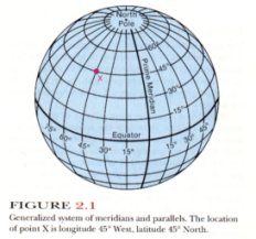
Spatial Coordinate Systems
Any system that allows you to use numeric values to identify the location of
a point on the surface of the Earth is termed a spatial coordinate system.
More generally, coordinate systems that allow you to locate a point anywhere
in space (e.g., locating a spacecraft somewhere between the Earth and the moon)
are also termed spatial coordinate systems.
Cartesian Coordinate System
A Cartesian coordinate system (named for Rene Descartes, a 17th century French
mathematician and philosopher) is a way of locating objects on a flat surface,
such as a map. Cartesian coordinates involve two axis that cross one another
at right angles. Point locations are identified by measuring where lines
connecting the point to the axis cross the axis. Cartesian coordinates provide
a very convenient way of locating points on flat surfaces. They are compatible
with standard Euclidean geometry, and unlike spherical coordinates, analyses
using Cartesian coordinates rarely require trigonometric operations. However,
Cartesian coordinates do not work well in non-Euclidian spaces, such as on the
curved surface of the Earth.