UTM Tools
The UTM Coordinate System
The Universal Transverse Mercator projection and grid system was adopted by
the U.S. Army in 1947 for designating rectangular coordinates on large scale
military maps. UTM is currently used by the United States and NATO armed
forces. With the advent of inexpensive GPS receivers, many other map users
are adopting the UTM grid system for coordinates that are simpler to use than
latitude and longitude.
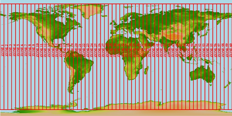
The UTM system divides the earth into 60 zones each 6 degrees of longitude
wide. These zones define the reference point for UTM grid coordinates within
the zone. UTM zones extend from a latitude of 80° S to 84° N. In the polar
regions the Universal Polar Stereographic (UPS) grid system is used.
UTM zones are numbered 1 through 60, starting at the international date line,
longitude 180°, and proceeding east. Zone 1 extends from 180° W to 174° W and
is centered on 177° W.
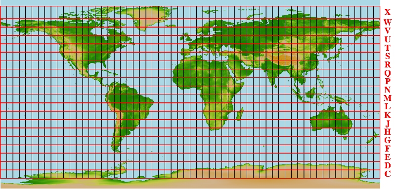
Each zone is divided into horizontal bands spanning 8 degrees of latitude.
These bands are lettered, south to north, beginning at 80° S with the letter
C and ending with the letter X at 84° N. The letters I and O are skipped to
avoid confusion with the numbers one and zero. The band lettered X spans 12°
of latitude.
A square grid is superimposed on each zone. It's aligned so that vertical
grid lines are parallel to the center of the zone, called the central
meridian.
UTM grid coordinates are expressed as a distance in meters to the east,
referred to as the "easting", and a distance in meters to the north, referred
to as the "northing".
Eastings
UTM easting coordinates are referenced to the center line of the zone known
as the central meridian. The central meridian is assigned an easting value of
500,000 meters East. Since this 500,000m value is arbitrarily assigned,
eastings are sometimes referred to as "false eastings".
An easting of zero will never occur, since a 6° wide zone is never more than
674,000 meters wide.
Minimum and maximum easting values are:
- 160,000 mE and 834,000 mE at the equator
- 465,000 mE and 515,000 mE at 84° N
Northings
UTM northing coordinates are measured relative to the equator. For locations
north of the equator the equator is assigned the northing value of 0 meters
North. To avoid negative numbers, locations south of the equator are made
with the equator assigned a value of 10,000,000 meters North.
Some UTM northing values are valid both north and south of the equator. In
order to avoid confusion the full coordinate needs to specify if the location
is north or south of the equator. Usually this is done by including the
letter for the latitude band.
If this is your first exposure to the UTM coordinate system you may find the
layout of zones to be confusing. In most land navigation situations the area
of interest is much smaller than a zone. The notion of a zone falls away and
we are left with a simple rectangular coordinate system to use with our large
scale maps.
Frequently, in land navigation, the zone information and the digits
representing 1,000,000m, and 100,000m are dropped. The 1m, 10m and 100m
digits are used only to the extent of accuracy desired. Note that it's the
smaller digits that are dropped in the notation used by the USGS on the edges
of their maps. For example 4282000 mN. becomes 82.
Because pilots and sailors navigate over much greater distances they still
favor the latitude longitude coordinate system.
The UTM Coordinate System's Benefits
A square grid
UTM Provides a constant distance relationship anywhere on the map. In angular
coordinate systems like latitude and longitude, the distance covered by a
degree of longitude differs as you move towards the poles and only equals the
distance covered by a degree of latitude at the equator. Since land
navigation is done in a very small part of the world at any one time using
large scale maps. The UTM system allows the coordinate numbering system to be
tied directly to a distance measuring system.
No negative numbers or East-West designators
Grid values increase from left to right and bottom to top. This is just like
the X Y Cartesian coordinate system you learned high school math class.
Simple Cartesian coordinate mathematics can be used. No spherical
trigonometry is required!
Coordinates are decimal based
Ones, tens, hundreds and so on. No more minutes and seconds to convert.
Coordinates are measured in metric units
All UTM coordinates are measured in meters. Most of the world has already
adopted the metric system. Now you won't need to remember how many feet are
in a mile. And what's that in yards?
UTM Coordinate Syntax
Standing at the road junction marked by a GPS unit set to display position in
UTM coordinates:

	10 S 0559741
	     4282182

The 10 S represents the zone you are in. The zone is necessary to make the
coordinates unique over the entire globe.

The top set of numbers, 0559741, represent a measurement of East-West
position, within the zone, in meters. It's called an easting.

The bottom set of numbers, 4282182, represent a measurement of North-South
position, within the zone, in meters. It's called a northing.

Many maps has Universal Transverse Mercator (UTM) grid lines spaced every
kilometer or 1000 meters. The vertical grid lines determine East-West
position and the horizontal grid lines determine North-South position.

Look along the bottom edge of a map at the labels for the vertical grid
lines. For instance:

	559 and 560000 mE.

The label, 560000 mE., reads "five hundred and sixty thousand meters East."
The label, 559, is an abbreviation for, 559000 mE. The two grid lines are
1000 meters apart. The horizontal grid lines are labeled in a similar manner.
Shorthand for UTM Coordinates
Most land navigation activities focus on a very small portion of the globe at
any one time. Typically the area of interest to an outdoorsman is less than
20 miles on a side. This focus on a small area allows us to abbreviate UTM
coordinates.

The zone information and the digits representing 1,000,000m, and 100,000m are
dropped. The 1m, 10m and 100m digits are used only to the extent of accuracy
desired.

A GPS unit might read

	10 S 0559741
	     4282182

Using a notation similar to the one found on a USGS topographic map, this
would be written as:

	Zone 10 S 559741 mE. 4282182 mN.

An abbreviated format for the same coordinates would look like:

	59    or 82     Describes a 1000m by 1000m square.
	597   or 821    Describes a 100m by 100m square.
	5974  or 8218   Describes a 10m by 10m square.
	59741 or 82182  Describes a 1m by 1m square.

The 100m abbreviated format, 597 821, and the 10m abbreviated format,
5974 8218, are the most commonly used.

Notice that the easting is reported first, followed by the northing. Remember
the phrase "read right up" to help you remember to read the easting from left
to right, followed by the northing from the bottom up.

Also notice that when you abbreviate coordinates you should not do any
rounding. 0559651 becomes 596 not 597. This ensures that your position is
still within the reported square. As accuracy decreases, the square gets
bigger.
UTM Coordinates on USGS Topographic Maps
All USGS topographic maps printed in the last 30 years or so include UTM grid
tick marks, in blue, on the margin of the map. For a short time period after
1978 the USGS was printing a fine lined UTM grid on their topographic maps.
They have since discontinued this practice.
Since most USGS 1:24,000 scale topographic maps do not have grid lines
printed on them, you will need to draw them in by hand. Start by finding a
flat surface to work on. Use a straightedge that is long enough to draw a
line across your map. Two to three feet long is a good length.
Line the straightedge up between two corresponding UTM tick marks along the
neat line (the edge) of the map. Remember that UTM grid lines are not exactly
North-South or East-West anywhere but in the center of a zone. This means
that the grid lines will not be parallel to the neat lines.
Using a mechanical pencil or a fine pointed pen draw a line between the two
tic marks. If you are using a pen, select one that has waterproof ink. In
addition, you will want to use a straightedge that has the edges lifted off
of the paper. This will help keep from leaving an ink smudge when you move
the straightedge. High quality straightedges will often have a thin piece of
cork stuck to the bottom. This helps keep the rule from slipping, and keeps
the edge off of the paper. A piece of masking tape centered on the bottom of
your straightedge will work also. Occasionally wipe of the edge of the
straightedge to avoid any ink build up.
Griding maps is tedious work. We all wish the USGS would go back to printing
the grid on the map. But even then, we would still need to grid our existing
maps. As you can see this is not the kind of thing you want to do on the hood
of a truck or using a flat rock. Grid your maps before you need them in the
field! In a pinch you can fold the map over on itself and use the edge of the
paper as a straightedge.
Photocopies of Maps
Frequently, you may use a photocopy of a small portion of a map rather than
the entire map. This cuts down the wear and tear on the original map and
allows several copies to be distributed among a group.
Make sure you transfer at least the large-print portion of the UTM grid
markings onto the photocopy. It's also helpful to provide scale and contour
information. Preprinted scale bars on Post-It note paper are available or
just make a copy of the scale bars and "cut and paste"
Avoid the temptation to change the scale of the map with the zoom on the
copier. If you use maps often you will have a good sense of distance. Alter
the scale and it will be harder to judge distances. Plus your overlay tools
will no longer be useful.
If you do change the scale using the copier, be sure and copy the scale bars
at the same time, so they will correctly reflect the new scale.
If you are marking roads, trails or boundaries on the photocopied map, avoid
obscuring the underlying feature with the mark. Pencil lines will usually
allow the feature to show through as will highlighter pens. There is nothing
more frustrating than needing to know what is under a big black mark on your
copy of the map.