For purposes of locating property lines and land descriptions
on legal documents, another system of coordinates is used in the United States and some
parts of Canada. This system is tied into the latitude and longitude coordinate system,
but functions independently of it. The basic block of this system is the section,
a rectangular block of land one mile long and one mile wide. An area containing sections is
called a township. While it was the intent of the original government land
surveyors to make each section an exact square of land, many sections and townships are
irregular in shape because of surveying errors and other discrepancies in laying out the
network.
The north-south lines marking township boundaries are called range
lines, and the east-west boundaries are called township lines. The
coordinate system of numbering townships has as a reference or beginning point, the
intersection of a meridian of longitude and a parallel of latitude, called principal
meridian and baseline, respectively. A particular township is identified by
stating its position north or south of the baseline and east or west of the principal
meridian. The system of numbering township and range lines is shown in figure 2.2. The
letter T along the right-hand margin of the large map stands for the word township,
and the letter R stands for the word range. The notation T.3 N., R. 1 E. is read,
“Township three north, Range one east.” Under this system, each township has a
unique numerical designation. Several principal meridians and baselines are used in the
coterminous United States, so that the township and range coordinate numbers are never
very large.
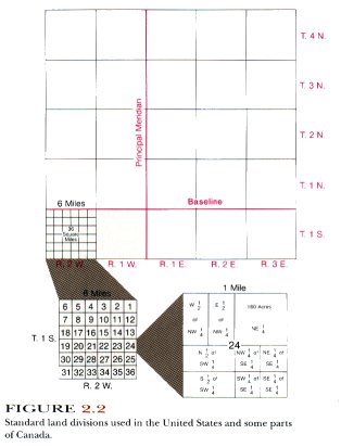
Each township consists of 36 one-square-mile sections that are
numbered according to the system shown in figure 2.2. One section of land contains 640
acres.
For purposes of locating either man-made or natural features
in a given section, an additional convention is employed. This consists of dividing the
section into quarters called the northeast quarter (NE Ľ), the southwest quarter (SWĽ),
and so on. Sections may also be divided into halves such as the north half (N˝) or west
half (W˝). The quarter sections are further divided into four more quarters or two
halves, depending on how refined one wants to make the description of a feature on the
ground. For example, an exact description of the 40 acres of land in the extreme southeast
corner of the map of section 24 in figure 2.2 would be as follows: SEĽ of the SEĽ of
Section 24, T. 1 S., R. 2 W.