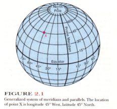
 The earth's surface is arbitrarily divided into a system of reference
coordinates called latitude and longitude. This coordinate
system consists of imaginary lines on the earth’s surface called
parallels and meridians (fig. 2.1). Both of these are best
described by assuming the earth to be represented by a globe with an axis
of rotation passing through the North and South poles. Meridians are circles
drawn on this globe that pass through the two poles. Meridians are labeled
according to their positions, in degrees, from the zero meridian, which by
international agreement passes through Greenwich near London, England. The
zero meridian is commonly referred to as the Greenwich meridian.
If meridional lines are drawn for each 15° in an easterly direction from
Greenwich (toward Asia) and in a westerly direction from Greenwich (toward
North America), a family of great circles will be created. Each one of the
great circles is labeled according to the number of degrees it lies east or
west of the Greenwich or zero meridian. The 180° west meridian and the 180°
east meridian are one and the same great circle, and constitute the
International Date Line.
The earth's surface is arbitrarily divided into a system of reference
coordinates called latitude and longitude. This coordinate
system consists of imaginary lines on the earth’s surface called
parallels and meridians (fig. 2.1). Both of these are best
described by assuming the earth to be represented by a globe with an axis
of rotation passing through the North and South poles. Meridians are circles
drawn on this globe that pass through the two poles. Meridians are labeled
according to their positions, in degrees, from the zero meridian, which by
international agreement passes through Greenwich near London, England. The
zero meridian is commonly referred to as the Greenwich meridian.
If meridional lines are drawn for each 15° in an easterly direction from
Greenwich (toward Asia) and in a westerly direction from Greenwich (toward
North America), a family of great circles will be created. Each one of the
great circles is labeled according to the number of degrees it lies east or
west of the Greenwich or zero meridian. The 180° west meridian and the 180°
east meridian are one and the same great circle, and constitute the
International Date Line.
A great circle represents the intersection of a plane that
connects two points on the surface of a sphere and passes through the center of the
sphere, in this case, the earth. The intersection of the plane with the surface divides
the earth into two equal halves—hemispheres—and the arc of the great circle is
the shortest distance between two points on the spherical earth.
Another great circle passing around the earth midway between
the two poles is the equator. It divides the earth into the Northern and Southern
Hemispheres. A family of lines drawn on the globe parallel to the equator constitute the
second set of reference lines needed to locate a point on the earth accurately. These
lines form circles that are called parallels of latitude, labeled according to
their distances in degrees north or south of the equator. The parallel that lies halfway
between the equator and the North Pole is latitude 45° North, and the North Pole itself
lies at latitude 90° North.
This system of meridians and parallels thus provides a means
of accurately designating the location of any point on the globe. Santa Monica,
California, for example, lies at about longitude 118° 29’ West and latitude 34°
01’ North. For increased accuracy in locating a point, degrees may be subdivided into
60 subdivisions known as minutes, indicated by the notation’. Minutes may be
subdivided into 60 subdivisions known as seconds, indicated by the
notation”. Thus, a position description might read 64° 32’ 32” East, 44°
16’ 18” South.
Meridional lines converge toward the North or South Pole from
the equator, and the length of a degree of longitude varies from 69.17 statute miles at
the equator to zero at the poles. Latitudinal lines, on the other hand, are always
parallel to each other. However, because the earth is not a perfect sphere but is slightly
bulged at the equator, a degree of latitude varies from 68.7 statute miles at the equator
to 69.4 statute miles at the poles. Thus, the area bounded by parallels and meridians is
not a true rectangle. U.S.G.S. quadrangle maps are also bounded by meridians and
parallels, but on the scale at which they are drawn, the convergence of the meridional
lines is so slight that the maps appear to be true rectangles. The U.S.G.S. standard
quadrangle maps embrace an area bounded by 7˝ minutes
of longitude and 7˝ minutes of latitude. These
quadrangle maps are called 7˝-minute quadrangles.
Other maps published by the U.S.G.S. are 15-minute quadrangles, and a few of the older
ones are 30-minute quadrangles.
Meridians always lie in a true north-south direction, and
parallels always lie in a true east-west direction. Magnetic north, however, is
the direction toward which the north-seeking end of a magnetic compass needle will point.
Because the magnetic poles are not coincident with the north and south ends of the
earth’s rotational axis, magnetic north is different from true north except on the
meridian that passes through the magnetic North Pole. The angle between true north and
magnetic north is called the magnetic declination, and is normally shown on the
lower margin of most U.S.G.S. maps for the benefit of those who use a compass in the field
to plot geological or other data on a base map (e.g., a U.S.G.S. standard quadrangle map).