 GPS or Global Positioning System is a satellite navigation
system funded and controlled by the U.S. Department of Defense (DOD).
GPS uses one-way satellite communication as a means to determine user
location based on a scheme using relative distances (the original intent
of the system was to supplement the tracking of ballistic missiles). The
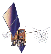
GPS Operational Constellation or "NAVSTAR"; consists of 24 Rockwell
International Block II satellites: 21 navigational satellites and 3 active
spares. Future plans include 21 Martin Marietta Block IIrs satellites.
GPS or Global Positioning System is a satellite navigation
system funded and controlled by the U.S. Department of Defense (DOD).
GPS uses one-way satellite communication as a means to determine user
location based on a scheme using relative distances (the original intent
of the system was to supplement the tracking of ballistic missiles). The
GPS Operational Constellation or "NAVSTAR"; consists of 24 Rockwell
International Block II satellites: 21 navigational satellites and 3 active
spares. Future plans include 21 Martin Marietta Block IIrs satellites.
At an altitude of 10,900 nautical miles, each satellite orbits earth every
12h period but repeats the same track approximately each 24h - 4m period.
With six orbital planes, (nominally 4 satellites in each) inclined at 55
degrees equatorial plane and equally spaced 60 degree apart, there are
between five and eight satellites visible from any point on the earth at
any given time.
The GPS constellation of 24 satellites is designed so that a minimum of five
are always observable by a users anywhere on earth. The receiver uses data
from the best four satellites above the horizon, adding signals from one as
it drops signals from another, to continually calculate its position.
GPS operation is based upon the concept of ranging and triangulation from a
group of satellites in space which act as precise reference points. A
GPS receiver measures distance from a satellite using the travel time of a
radio signal. The course/acquisition (CA) code one of the two
Pseudo-Random Codes
of each satellite, contains information on the satellite's position, the GPS
system time, its clock error, and the health and accuracy of the transmitted
data. GPS satellites have very accurate atomic clocks in order to calculate
signal travel time. Knowing the speed at which the signal traveled
(approximately 186,000 miles per second) and the exact broadcast time, the
distance traveled by the signal can be computed from the arrival time
(velocity x time = distance).
The GPS receiver matches each satellite's CA code with an identical copy of
the code contained in the receiver's database. To make the measurement we
assume that both the satellite and our receiver are generating the same
Pseudo-Random Codes at exactly the same time. By comparing how late
the satellite's Pseudo-Random Code appears (shifting its copy of the
satellite's code, in a matching process, and comparing this shift with its
internal clock compared to the receiver's), the receiver can calculate how
long it took the signal to travel from the satellite to the receiver. The
distance derived from this method of computing distance is called a
pseudo-range because it is not a direct measurement of distance, but a
measurement based on time. Pseudo-range is subject to several error sources:
for example, an ionospheric delay, and time disparities between the atomic
clocks in the satellites and the GPS receiver.
In addition to knowing the distance to a satellite, a receiver needs to know
the satellite's exact position in space; this is known as its ephemeris. Each
satellite's signal transmits ephemeris information about its exact orbital
location. The GPS receiver uses this information to precisely establish the
position of the satellite.
Using the calculated pseudo-range and the position information supplied by
the satellite, the GPS receiver mathematically determines its position by
triangulation. The GPS receiver needs at least three satellites with timing
corrections from a fourth satellite to yield an unaided, unique, and true
three-dimensional position (latitude, longitude, and altitude) and time
solution. The GPS receiver computes navigational values such as distance
and bearing to a waypoint, ground speed, etc., by using the GPS receiver's
known latitude/longitude and referencing these to a database built into the
receiver.
GPS Positioning Services:
Precise Positioning Service (PPS): Authorized users with cryptographic
equipment and keys and specially equipped receivers use the Precise
Positioning System. U. S. and Allied military, certain U. S. Government
agencies, and selected civil users specifically approved by the U. S.
Government, can use the PPS.
- PPS Predictable Accuracy
- 22 meter Horizontal accuracy:
- 27.7 meter vertical accuracy
- 100 nanosecond time accuracy
Standard Positioning Service (SPS): Civil users worldwide use the SPS
without charge or restrictions. Most receivers are capable of receiving and
using the SPS signal. The SPS accuracy is intentionally degraded by the DOD
by the use of Selective Availability.
- SPS Predictable Accuracy
- 100 meter horizontal accuracy
- 156 meter vertical accuracy
- 340 nanoseconds time accuracy