What is an Ellipsoid?
As everybody knows now, the world is not flat. Actually, it is not round
either: it is flattened at the Poles. It resembles a three dimensional
ellipse called an ellipsoid. An ellipsoid can be defined by a number of
mathematical characteristics. As our knowledge of the world has increased
over the centuries, we have come to know the dimensions and shape of the
world more accurately. Mathematical models of the shape of the world have
therefore become more and more precise, and it has become necessary to change
to a more accurate model. The new, more accurate model is called Geodetic
Reference System 1980 (GRS80).
What is a Datum?
A datum defines how a coordinate system is seated over the ellipsoid. It
describes the model that was used to match the location of features on the
ground to coordinates and locations on the map. Maps all start with some form
of survey. Early maps and surveys were carried out by teams of surveyors on
the ground using transits and distance measuring "chains". Surveyors start
with a handful of locations in "known" positions and use them to locate other
features. These methods did not span continents well. Frequently they also
did not cross political borders either. The "known points" and their
positions are the information that the map datum is based. As space based
surveying came into use, a standardized datum based on the center of the
earth was developed.
The origin of the new NAD83 system is the centre of mass of the Earth,
whereas the old North American Datum 1927 (NAD27) had a different origin,
making it useful only in North America. GPS receivers also use the centre of
mass of the Earth as their system's origin.
The Global Positioning System uses an earth centered datum called the World
Geodetic System 1984 or WGS 84. WGS 84 was adopted as a world standard from
a datum called the North American Datum of 1983 or NAD 83. For all practical
purposes there is no difference between WGS 84 and NAD 83.
Most USGS topographic maps are based on an earlier datum called the North
American Datum of 1927 or NAD 27. (Some GPS units subdivide this datum into
several datums spread over the continent. In the Continental United States
use NAD27 CONUS.) In the Continental United States the difference between
WGS 84 and NAD 27 can be as much as 200 meters. You should always set your
GPS unit's datum to match the datum of the map you are using.
Every map that shows a geographic coordinate system such as UTM or Latitude
and Longitude with any precision will also list the datum used on the map.
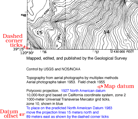
On a USGS topographic map the datum information is in the fine print at the
bottom left of the map. The datum will always be NAD 27. There may be
information on how many meters to shift a position to convert it to NAD 83.
Think of this as the error that will be introduced if you leave your GPS unit
set to WGS 84. A dashed cross in the SW and NE corners of the map gives a
visual indication of the difference between the two datums.
If you have somehow set your GPS to use the Borneo Datum of 1818, it's hard
to say how far off you position may be. Let's just sat that this "datum
thing" is something you need to pay attention to.
If you are coordinating with aircraft, they will likely have their datum set
to WGS 84, as most aviation charts now use WGS 84. Should you worry about the
difference in datums? Typically a pilot will not have any difficulty locating
you on the ground if you can get them within several hundred meters of your
location. If you are engaged in a mission that requires more precision, then
your datums should match.